4 Hikes Close to Point Reyes Station

By Matt Dolkas,
Senior Manager, Marketing
June 15, 2022
I love hiking near Point Reyes Station.
If you’ve spent any time in the area then you know that there’s a special mojo in this corner of Northern California, a natural magic that seems to culminate here in the unofficial capital of West Marin. Hiking the trails near Point Reyes Station, it’s hard not to feel transported in time — a landscape that still looks and feels much as it has for decades.
Of course, this is no happy accident. Most visitors to the area don’t realize that the 71,028 acres within the Point Reyes National Seashore is surrounded by an additional 54,459 acres of protected agricultural land. Since 1980, the Marin Agricultural Land Trust (folks just call us “MALT”) has been working hard to conserve the region’s vital farm and ranch land from the threat of development. For me, this is the secret sauce and why I love hiking these trails, an opportunity to experience this unique mosaic of protected land.
Point Reyes Station happens to be smack dab in the middle of this natural paradise. And the cherry on top of this proverbial sundae is that after your hike you’re not far from downtown and the deliciousness of the Bovine Bakery and Brickmaiden Breads, fresh cheese at the Cowgirl Creamery or the authentic funk and cold drinks at the Old Western Saloon. The Palace Market also has just about everything you might need should you have forgotten your stash of local cheese, honey wine or other picnicking essentials. There’s no time to waste – the trails await!
Here are, in my humble opinion, some of the best hikes close to Point Reyes Station:
Bolinas Ridge Trail
Distance: up to 22 miles round trip (shorter options available)
Elevation gained: 2,470 ft
Wheelchair accessible: No
Dog-friendly: Yes, on-leash only
Find driving directions by clicking here
Restroom: No
Managing Agency: National Park Service
Offering some of the best vistas in the area, the Bolinas Ridge Trail makes for an incredible introduction to the sweeping landscapes of West Marin. With 360 degree views of the surrounding ranch and farmland, this out and back is what hiking near Point Reyes Station is all about.
The first 2.4 miles gradually ascend an open ridgeline, offering sweeping views of Olema Valley to the west, Tomales Bay to the northwest, and MALT-protected Black Mountain to the north. This makes for a wonderful, shorter, out-and-back on its own (4.8 mile round trip). From here, the trail skirts the trees along the ridge, before entering groves of coastal forest at 5.5 miles then California chaparral, before dropping back into redwood forest.
The Bolinas Ridge Trail spans 11 miles from its northern trailhead along Sir Francis Drake Boulevard to its southern terminus on the Fairfax-Bolinas Road. Retrace your steps at any point to complete this hike.
Tomales Bay Trail
Distance: 2.6 mile round trip
Elevation gained: 259 ft
Wheelchair accessible: No
Dog-friendly: No
Find driving directions by clicking here
Restroom: No
Managing Agency: National Park Service
As one of the closest trails to Point Reyes Station, this trail is conveniently just a short drive north of town. Follow the single track path through active pastures (be sure to close the gates behind you!), along the coastal bluffs and the edge of the restored Giacomini Wetlands.
Birders will delight in the abundance of feathered friends and rich avian habitat, including a vibrant stock pond. The trail’s big boulders are also fun for kids (and the young at heart) to climb on. Be sure to pack layers as the wind and fog can make for chilly temperatures, even in the summer months.
Since 1980, the Marin Agricultural Land Trust (MALT) has been working to protect farm and ranchland from the threat of development — work that is now more important than ever in the face of a rapidly changing climate. Learn more here.
Olema Valley Trail
Distance: 10.5 mile round trip (shorter options available)
Elevation gained: 1,328 ft
Wheelchair accessible: No
Dogs: Yes (on leash)
Find driving directions by clicking here
Restroom: Yes
Wheelchair accessible: No
Managing Agency: National Park Service
Tucked into this sheltered, coastal valley — where the fog rolls in thick and lingers into the morning — the Olema Valley showcases the wetter, more forested habitat of our local landscapes. Follow this trail through a lush forest of Douglas fir, California bay laurel and coast redwood trees.
The Olema Valley Trail stretches between two trailheads, Five Brooks Trailhead in the North, and Olema Valley Trailhead in the South. Parking is available at either trailhead (Five Brooks Trailhead has both a restroom, and a much larger parking area) and it’s a fantastic hike from either direction.
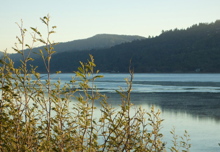
Millerton Point Trail
Distance: 1.2 miles
Elevation gained: 62 ft
Wheelchair accessible: Yes (more info here)
Dogs: Yes (on leash)
Find driving directions by clicking here
Restroom: Yes
Managing Agency: California State Parks
This gentle trail meanders along the edges of Tomales Bay for world-class views of the surrounding agricultural landscape and across the water into the fog drenched promontory of Tomales Point. At low tide, enjoy a walk along the water at Alan Sieroty Beach.
The relatively easy trails and scenic vistas make Millerton Point a wonderful impromptu adventure or outing with little ones. It also makes for a fantastic picnicking destination so be sure to grab some local cheese and bread on your way out of town at the Palace Market in downtown Point Reyes Station.
– Authored by Matt Dolkas, Senior Manager of Marketing and Communications
Eat Local, Stay Connected
Every time you shop, you can choose to support your local food economy and the farmers and ranchers who help steward this vital landscape. Start today!